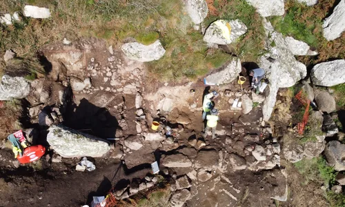
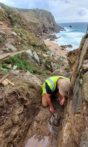
 Over September and October 2021 Penwith Landscape Partnership (PLP) have been working closely with Cornwall Archaeology Unit (CAU) to excavate the remains of St Levan's chapel, a tiny Medieval chapel clinging to the cliff edge overlooking Porth Chapel, St Levan. Prompted by concerns for its condition and survival after a severe flash flood in 2018 plus advancing coastal erosion, Historic England and the PLP decided to look into making a record of the site before more material was lost to the elements. Reputed to be one of Cornwall’s earliest Christian chapels, despite numerous excavations in the 20th century, no firm date or full interpretation has ever been possible for the monument.
Joint funding from the PLP and Historic England who appointed the project a generous grant to explore effective ways of managing loss to coastal archaeological sites allowed a full excavation of this Scheduled Monument to happen.
Part of the project was to ascertain a way forwards for a site in rapid decline- record passively as damage occurs over time, or record actively before loss begins? Often used to seeing Scheduled Monuments in either active management or an undisturbed passive state, it is unusual to see a site so obviously deteriorating in such a dramatically precarious location. However, it is this pressing risk of loss that allows the balance between a more passive management approach and action to be tipped in favour of action. And, whilst the loss of a site is a sad loss to the archaeological record, an opportunity can be found here to learn as much as possible about the site before it is gone. Excavation of a site is by its nature destructive, and so is avoided if possible. This is particularly so on Scheduled Monuments which are deemed nationally important and where, as much as is possible, the emphasis is on preserving and keeping stable the above and below ground remains for the future. The more dynamic damage to Britain’s coastline that we see today, exacerbated by climate change and increasingly common extreme weather events means that a rising number of coastal archaeological sites around the country are under threat. In this case, one of west Cornwall’s mysterious Medieval clifftop chapels.
Due to the extremely precarious location of the site the digging team had to be harnessed up for their safety and occasionally lowered over the cliff edge to excavate the outside of the chapel on the seaward facing southern side. The site team worked closely with geotechnical specialists IBEX who managed safety and manoeuvred fallen rocks away from this tiny site.
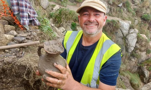
 Preliminary findings suggest a period of activity on the site during the Medieval period before it apparently fell out of active use, possibly as the result of damage from a landslide. The remains of a previously unknown building have been found adjacent to the chapel itself on the eastern side, almost mirroring in size and shape the small building (referred to by Charles Thomas after his investigations in the 1950’s as the cell, and presumed to be accommodation for a hermit or similar custodian of the chapel ) which abuts the chapel to the west. Although these buildings all abut each other it is hard to tell if they are all contemporary or represent a series of occupations over time. Samples have been taken for dating alongside environmental samples and a few finds for analysis. Most notably a beautiful and complete jug likely dating to the late 14th/early 15th century was found buried under a considerable depth of landslide soil just outside the southern wall of the chapel adjacent to the stream and inside the newly discovered building there.

No material evidence (finds) of Early Medieval occupation was found although it cannot be ruled out and it may be possible that the small previously unknown building is of an earlier date. However, as so little remains here of the buildings and very few finds have been recovered, it will be the soil dating samples taken that we would hope to shed more light on time periods of– a technique called Optically Stimulated Luminescence will be used in an attempt to date samples taken from below the walls. We do know however that during the medieval period the chapel and western cell were well-roofed in slate, had plaster coated interior walls which were painted and had glazed floor tiles. All pointing towards a site that although small, was well set up for visitors. The holy well seems also to have been a key part of this complex of buildings with the presence of culverts in the floors of both smaller buildings which seem to correlate with the flow of water from (presumably) the holy well above.
Now the work of excavating and recording has been completed we will monitor the decline of the remains over the remainder of the project and reinstatement of spoil material removed from the monument during excavation. By chance there is in the close vicinity a population of rare burrowing bees, and the exposed soil face of the chapel building bank and the spoil heap of nutrient poor rab or sub soils provide an excellent additional habitat for burrowing bees, wasps and ants. We hope to spend a day or two consolidating these new habitats and the monument itself after site works finish. We will aim to make the site as stable as possible, given the precarious location of the with the hope of allowing it to last as long as possible but there is no doubt that some of it will be lost to the sea in coming years. The south and east sides abutting the stream are particularly fragile and in the most precarious location.
The top of the south wall used to be the route of the coast path before it was diverted for safety reasons and appears to be practically hanging on fresh air. A somewhat alarming thought when you consider it was and still is occasionally used as a path! Any visitors to the site should bear in mind that this is a dangerously eroding part of the coast and the coast path route has already been moved away from the cliff edge here for safety reasons. Please also bear in mind that these buildings are part of a Scheduled Monument and therefore it is an offence to cause damage and a lot of the material here is loose and easily disturbed. A great view of the site can be had from the opposite side of the stream on the path down to the beach.
Once all the excavation results are in there will be a full report written and a sign produced for the coast path to let folks know about the chapel below.
Accurate 3D models were taken of the site before, during and after works so there is as complete a record as possible of what is and was there. We are pleased to be able to share with you a 3D model of the jug that was discovered, which can be found on Sketchfab, or by exploring below. You can explore all the 3D models of the excavation by clicking here.


