First and Last – Our Living Working Landscape
Hen Leow - Dastrehevyansow Istorek
Ancient Sites - Historical Reconstructions
These reconstructions have been drawn by digital artist Phoebe Herring and show how some of the sites in West Penwith might have looked at various points during their active lifespans. The heritage of West Penwith, as a living historic landscape is diverse, long standing and incredibly interlinked. We find that often sites are reused multiple times: lived in or used for a time then abandoned, only to be revisited at a later time period or periods. These drawings show a snapshot of a place in history from one time period based on the archaeological evidence we have available to us now. It is however, entirely likely that much more is hidden beneath the surface of these sites that future investigations might bring to light.
Bartine Castle
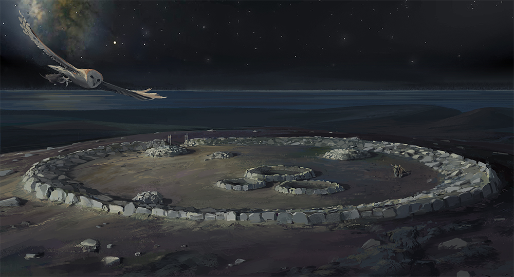
Bartine Castle is a dual period site, consisting of an initial Bronze Age (2500 BCE - 800 BCE) circular enclosure with circular stone edged features identified as barrows or cairns inside, later modified in the Iron Age (800 BCE - 43 CE) to be a larger version of much the same sort of feature, a circular enclosure with cairns inside. It seems unlikely that these smaller structures are hut circles. This reconstruction shows the site at night on the Autumn Equinox, the stars have been regressed to their natural position as they would have appeared in the middle of the Bronze Age.
Bosiliack Settlement

This is a Bronze Age settlement consisting of some fourteen hut circles, nestled within their own associated prehistoric field system of irregularly shaped fields and clearance cairns which covers some 11 hectares. Eleven of the huts are single circles, two are two roomed and one is three roomed. Archaeological finds in the vicinity of the hut circles are consistent with domestic occupation, and ritual monuments such as cairns and an entrance grave lie within the surrounding field systems (with a number of stone circles and other burial monuments in the slightly wider vicinity). It would be easy to imagine a well settled community, firmly established within their local landscape.
Caer Bran Hillfort

This Bronze Age ring cairn enclosure or hillfort with three internal, smaller ring cairns was later modified into an Iron Age hillfort with a large external ditch and rampart encompassing the earlier Bronze Age one. A single hut circle inside the fort has been attributed to this later period of activity. The reconstruction shows how this second phase of activity in the Iron Age might have looked during the final stages of the site’s modification for reuse.
Caer Bran is a Cornish place-name meaning 'the fort of Bran'; 'Bran the Blessed' was a mythological warrior king of prehistoric Britain who figures in early Welsh myths (cf. The Mabinogion) and whose name is often associated with hillforts and high places. More mundanely, 'bran' is Cornish for 'raven', and an alternative derivation would be 'fort of the raven'.
Castle-an-Dinas Hillfort

A large circular Iron Age hillfort with four concentric ramparts consisting of banks and ditches, defensively configured (ditches outside the bank) with a complex entrance and multiple hut circles inside. It is thought that this striking hillfort was constructed on the location of a Neolithic hilltop enclosure although little evidence of this remains visible today. This reconstruction shows how grand it might have been, in its prominent position overlooking Mounts Bay during the height of its occupation in the Iron Age.
Goldherring Courtyard House Settlement

An Iron Age or Romano British (approximately 43 CE - 405 CE) courtyard house settlement consisting of a single, large courtyard house and an unusually large and defensive enclosure wall and ditch. Courtyard House settlements are particular to West Penwith during this time period but uniquely, this settlement also has a forge inside it attributed to tin production. It was re-occupied several times between the 2nd and 6th centuries CE and the forge was later modified during the medieval period to work iron. This reconstruction shows how it might have looked during the end of its Romano British occupation period.
Gurnard's Head Cliff Castle

The site is an Iron Age Cliff Castle known as Trereen Dinas, built on the promontory of Gurnard's Head. Comprising some 18 hut circles and a series of large defensive ditches and banks, which would have effectively cut off the rocky promontory from the mainland. This would have been an easily defensible area where people could live. It is not known if occupation was permanent or occasional here, but the buildings are all clustered on the leeward side of the rocks to shelter them from the prevailing winds.
Kemyel Crease Market Garden Plots

Dating to the 19th century, these market garden plots on the clifftop at Kemyel Crease, between Lamorna and Mousehole, show up on the 1840 tithe maps, making them the earliest recorded garden plots in Penwith. They were referred to at this time as the ‘Garden of Eden’ and would have consisted of small walled garden plots, hugging this south facing cliff edge slope, often used for producing early spring flowers for the London flower markets that opened up as a viable market for such things with the advent of steamboats and the railway. They continued in use as garden plots for flowers and early potatoes until the mid-20th century.
Madron Baptistry

The building of Madron Baptistry is part of a Medieval complex which also includes the holy well and the chapel enclosure that sit on Well Moor, just outside Madron village. Originally dedicated to Saint Ithy, it became later dedicated to Saint Maddern and appears to have been part of a wider water management complex taking water from the well by leat not only to the chapel building, but further afield to the estate of Landithy (now a farm) and then later, onwards to Madron churchtown.
Water from the holy well was once carried by leat into the chapel building itself where it collected in a corbelled cistern and then ran out of the building along a small open overflow channel or leat. Long standing folklore associated with the well and its waters refer to healing properties, in particular around the feasts of Corpus Christi in the church calendar (May-June time); and more latterly recorded as a site for divination and guidance by young women, and a curative for children’s skin diseases.
Sperris Roundhouse Settlement

This is a multi period late Bronze Age and early Iron Age roundhouse settlement on the shoulder of Sperris Hill overlooking the coast. This reconstruction presents an image of what the settlement might have looked like when the houses were first built in the late Bronze Age. This settlement is thought to be a seasonally inhabited one when people were grazing cattle on the higher land, probably in summer months. A series of drove ways ran between this higher land and the coastal fields and settlements to the north west, where the population and their animals would have spent the other part of the year.
Bakers Pit Banjo Enclosure

A rather enigmatic type of enclosure, thought to date to the Iron Age and unusual for Cornwall but thought to be for animal management. So called because of their rough banjo shapes the one at Bakers has a very short neck and seems to be associated with a few round houses. Hidden today by dense vegetation and overlain by more recent field boundaries and some mining pits it is very hard to see any of the remaining features or indeed make much sense of them today. On the ground the remains of the enclosure bank is about 15cm high so this drawing really bring it to life.
St Levan's chapel

A clifftop chapel and hermitage dating to the Early Medieval period and then embellished in the Medieval period this cluster of three buildings sites right on the edge of the cliff above Porth Chapel. The earlier buildings seem to be the small cells either side of the chapel and these both incorporate gullies which channel water, possibly from the holy well on the cliffs above though them. The chapel building itself sits between these cells and is a small rectangular structure of simple design. It was enhanced in the 13th century and would have had a richly painted interior for all that its outside would have likely been fairly plain. This drawing shows the site in its final format circa 1300.
Tregaminion medieval chapel and holy well

An interesting complex of medieval baptistry chapel and holy well, one of several that sit along the clifftops of West Penwith and which are often associated with earlier chapels on the same site, in some cases, the very earliest Christian structures in the area. Often thought to reuse earlier holy well sites these clifftop chapels were important sites for the local community and were used into the 14th century after which point they were often replaced or became secondary to the village parish churches. The one at Tregaminion seems to have had an extensive cobbled surface around it whcich incorporates a large fallen stone within the precinct area. this reconstruction drawing shows how it might have looked in the early 14th century.


